Bihar’s 220-km Riverfront Expressway Plan Poised to Transform Real Estate Landscape
Bihar's 220-km Riverfront Expressway plan may open next real estate hotspots in the state
The state government’s ambitious three-corridor infrastructure project aims to boost regional connectivity and unlock potential growth zones along the Ganga and Gandak rivers.
Infrastructure development in Bihar is set for a major overhaul as the state government unveils a blueprint for a 220-kilometre riverfront expressway network. By leveraging the natural corridors of the Ganga and Gandak rivers, the project aims to move beyond traditional highway building, focusing instead on integrated regional connectivity. For the construction and property sectors, this plan serves as a potential game changer, likely to open new real estate hotspots that have historically remained underdeveloped.
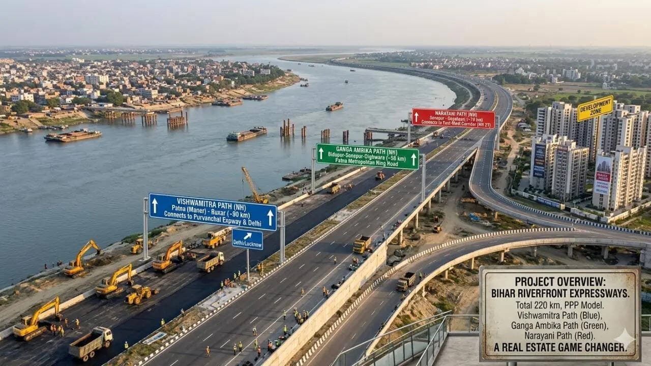
Mapping the Strategic Corridors
The development plan is comprised of three distinct four-lane corridors, each serving a specific strategic purpose. The most significant of these is the Vishwamitra Path, a 90-km stretch connecting Maner near Patna to Buxar via Arrah. Its primary value lies in its integration with the Purvanchal Expressway in Uttar Pradesh. By bridging this gap, the state is effectively creating a high-speed link to Delhi, which is expected to slash travel times significantly and enhance logistics efficiency between the national capital and Bihar.
Complementing this is the Ganga Ambika Path, a 56-km route designed to bridge Bidupur, Sonepur, and Dighwara. This project is specifically targeted at decongesting the Patna metropolitan region, facilitating smoother movement for suburban commuters and potentially shifting the focus of commercial expansion toward the northern banks of the river. Finally, the 74-km Narayani Path, tracing the Gandak river from Sonepur to Gopalganj, will serve as a vital link between northern Bihar and the existing East-West Corridor, providing a much-needed boost to the state’s northern logistics backbone.
Economic Implications for Investors
While the primary objective remains improved transportation, the long-term impact on the state’s property market is becoming a focal point for stakeholders. Historically, infrastructure projects of this magnitude in India act as catalysts for land value appreciation, as better connectivity turns peripheral, low-cost land into prime industrial or residential hubs. Investors are already looking at these stretches as the next frontier for growth, as the improved path of travel makes previously inaccessible riverfront areas viable for modern development.
Beyond the immediate boost to real estate, this plan represents a significant shift in how the state views its natural geography. By aligning major expressways with riverfronts, the government is attempting to balance the need for rapid transit with the geographical constraints of the region. If executed according to the current plan, these three paths could fundamentally reshape the economic geography of Bihar, turning once-isolated riverine pockets into active, well-connected nodes of trade and living.
The PoliticalPedia Editorial Desk brings verified, sourced political news and analysis from across India.